
‘Blizzard of 2015’ HQ: Preparations, cancellations, and word from the street
With our first major storm approaching, there isn’t much more to do but ride it out. Making sure you’re prepared for the Blizzard of 2015 is key.


MANCHESTER, NH – With our first major storm approaching, there isn’t much more to do but ride it out. Making sure you’re prepared is key.
Word just in that Manchester School District will close Tues. Jan. 27 and Wed. Jan. 28. Click here for the update from City Hall as of 1 p.m. Monday. All extracurricular school activities will cease as of 6 p.m. Monday.
Massachusetts has issued a statewide travel ban. If you commute to work in Massachusetts, you have the day off.
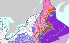
Latest update from the National Weather Service as of 4 a.m. on what is being already called “The Blizzard of 2015.”
Jan. 26, 2015 4 a.m. DANGEROUS COASTAL STORM TO AFFECT THE AREA MONDAY NIGHT INTO TUESDAY NIGHT. AN AREA OF LOW PRESSURE WILL MOVE THROUGH THE CAROLINAS TODAY AND EXIT OFF THE EAST COAST. THIS STORM WILL STRENGTHEN SIGNIFICANTLY OFF THE SOUTHERN NEW ENGLAND COAST BY TUESDAY MORNING. SNOW WILL QUICKLY SPREAD INTO THE AREA FROM SOUTH TO NORTH LATE MONDAY INTO EARLY TUESDAY AND WILL LIKELY BE HEAVY AT TIMES DURING THE DAY TUESDAY. WINDS WILL BE STRONG ON AND NEAR THE COAST PRODUCING A PERIOD OF BLIZZARD CONDITIONS. EASTERN HILLSBOROUGH NH- INCLUDING THE CITIES OF MANCHESTER and NASHUA BLIZZARD WARNING IN EFFECT FOR EASTERN HILLSBOROUGH COUNTY FROM 10 P.M. TO 4 A.M. Jan 27 WINTER STORM WARNING IS CANCELLED * HAZARD TYPES: HEAVY SNOW AND STRONG WINDS. * ACCUMULATIONS: SNOW ACCUMULATION OF 18 TO 24 INCHES. * TIMING: SNOW WILL BEGIN LATE MONDAY IN SOUTHERN NEW HAMPSHIRE. BLIZZARD CONDITIONS WILL BE MOST LIKELY DURING THE DAY TUESDAY. SNOW WILL WIND DOWN LATE TUESDAY BUT LINGER INTO WEDNESDAY. * IMPACTS: WHITEOUT CONDITIONS WILL MAKE TRAVEL EXTREMELY DANGEROUS IF NOT IMPOSSIBLE. STRONG WINDS MAY LEAD TO SCATTERED POWER OUTAGES. TEMPERATURES IN THE TEENS AND SINGLE DIGITS COMBINED WITH WINDS WILL LEAD TO BITTERLY COLD WIND CHILLS. IF YOU ARE STRANDED OUTDOORS IT COULD BE POTENTIALLY LIFE THREATENING. * WINDS: NORTH 10 TO 20 MPH WITH GUSTS UP TO 45 MPH. * TEMPERATURES: 12 TO 20. PRECAUTIONARY/PREPAREDNESS ACTIONS: A BLIZZARD WARNING MEANS SEVERE WINTER WEATHER CONDITIONS ARE EXPECTED OR OCCURRING. FALLING AND BLOWING SNOW WITH STRONG WINDS AND POOR VISIBILITIES ARE LIKELY. THIS WILL LEAD TO WHITEOUT CONDITIONS MAKING TRAVEL EXTREMELY DANGEROUS. DO NOT TRAVEL. IF YOU MUST TRAVEL HAVE A WINTER SURVIVAL KIT WITH YOU. IF YOU GET STRANDED STAY WITH YOUR VEHICLE.
Useful links
Power outage maps
- PSNH (Eversource Energy)
- Unitil
- National Grid/Liberty
- NH Electric Co-op
Dial 511NH for traffic updates/road closure information
Cancellations (Updated Jan. 26 9 a.m.)
We expect lots of cancellations – especially since driving in the height of the storm is a bad idea, for everyone’s safety.
Click here for WMUR’s comprehensive list of closings. If you have others you’d like to post here, please e-mail your cancellations to robidouxnews@gmail.com.
Schools:
Manchester School District: Closed Jan. 27-28.
Saint Anselm College closed January 27, 2015. Updates at http://www.anselm.edu
Air Travel:
11 a.m.: Logan Airport will remain open but last scheduled flight out is 7:30 p.m. Monday night, according to MassLive.
Manchester-Boston Regional Airport is receiving cancellations from many airlines.
Airline information/flight tracking for Manchester-Boston International (MHT)
Check with your airline if you have a flight scheduled.
Morning flights Jan. 26 were still on time, but Delta and United flights scheduled for afternoon and evening were canceled ahead of the storm.
The National Weather Service says the predicted nor’easter could bring heavy snow, powerful winds and widespread coastal flooding through Tuesday. A blizzard warning was issued for a 250-mile stretch of the Northeast, including New York and Boston.
Events:
- Photo 360 Workshop in Salem.
- Plymouth State College event to honor Gov. John Lynch with the Robert Frost Contemporary American Award on Jan. 27 featuring Boston Red Sox President and CEO Larry Lucchino as keynote speaker at the Radisson Hotel has been rescheduled for Tuesday, Feb. 3.
Emergency Contacts (add these numbers to your cell phone)
Note: Always dial 911 in an emergency. However, the quickest method of communication when possible in a situation that is non-life-threatening is dialing police and fire departments directly.
- Manchester Police: 668-8711
- Manchester Fire: 669-2256
- Department of Public Works (for snow removal related calls): 624-6444
- American Medical Response ambulance service for Manchester: 800-322-0471
Manchester NH Connect

If you use a smart phone, now is a good time to download the free Manchester NH Connect mobile app, if you haven’t already. You can report problems and outages and instantly connect to city-based emergency services and information using your phone.
Especially in the event of a power outage, a smart phone can become an invaluable tool. Remember to keep your phone charging for as long as you have power throughout the storm.

Top 10 items for a winter survival kit:
Water: At least a 3-day supply; one gallon per person per day
Food: At least a 3-day supply of non-perishable, easy-to-prepare food
Flashlight & extra batteries: (candles and matches are helpful, too!)
Battery-powered or hand-crank radio
First aid kit
Personal hygiene items (toiletries, etc.)
Cell phone with chargers (consider an external battery pack.)
Family and emergency contact information
Extra cash
Baby and/or pet supplies (bottles, formula, baby food, diapers) (collar, leash, ID, food, carrier, bowl.)
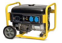
Click here for safe generation operation tips from ManchesterNHMLS.com
Click here for a rundown on how best to be prepared, from Public Service of NH.
Click here to set up your phone to receive text messages on power outage updates from PSNH. Downed lines should be reported to PSNH immediately at 1-800-662-7764. You can also follow @PSNH via Twitter and report outages there.
Extras: What are you forgetting?
- In advance of a severe storm, put refrigerator and freezer at coldest settings. Do this a half day before the storm is scheduled to hit. Keep a blanket handy to throw over these appliances for added insulation, if need be. (Return settings to their normal position as soon as the crisis has passed.)
- Plan to live without everyday tools that require electricity to function:
- know how to manually open an electronically controlled garage door
- have a manual (non-electric) can opener for backup
- use a sump pump to clear water from your basement? Be prepared to call the local fire department for help if you lose power for very long and water collects in your basement.
- Do any of your family’s medications require refrigeration? Pets’ medications? Be sure you know if these items will be affected by a prolonged interruption of power. Talk with your pharmacist ahead of time. Keep a small cooler handy.
- Periodically back up computer data to prevent loss during a sudden outage.
- Shovel snow away from dryer vents, heaters, wood stove exhaust and hydrants during heavy snowfall.
- Invest in an Uninterruptible Power Supply (UPS). During a momentary power outage, the UPS will continue to provide power to your personal computer. (A UPS is not designed to operate a computer indefinitely, only long enough to allow users time to save their work and shut down properly.)
- Plug sensitive computer and electronic equipment into surge suppressors or surge protectors. A surge suppressor diverts excessive electrical energy away from your equipment to an electrical “ground” where it disappears without doing any harm.
- If you don’t have surge protectors/suppressors, unplug your sensitive equipment. Voltage irregularities can occur for any number of reasons during or after a storm, especially if there has been damage on or near your home. The safest thing to do is to unplug any sensitive electrical devices (TV, VCR, stereo, microwave, computer, answering machine, garage door opener, etc.).


